So in keeping with this years theme of getting back into the things I love to do, I set out to climb Hagar Mountain on Sunday. I had been eyeing this peak from Loveland Pass during the ski season and now that we've hit mid July I figured the snow pack would be down enough to do a ridge run from Loveland Ski Area. A snow climb in the late spring would be great in this area after the snow pack settles. Hagar Mountain is 13,195' and sits at the north end of the Dry Gulch Basin.
 Hagar Mountain is the high point on the left center of the photo
 The Continental Divide Ridge line was my ascent and descent route. After gaining most of my vertical for the day in the first couple of miles from the ski area, the ridge run was a tedious up and down hovering around 13,000 feet the whole way.
 The saddle before my final ascent to the peak left me looking at this. The ridge dropped from 13,000 to 12,600 then back up to 13,195 to the summit. A bit of a grind but worth it.
 This is the summit formation, the climb was all class 2 to this point. The final scramble to the top is considered class 3 with a couple class 4 moves thrown in. The north side of the summit (left in photo above) is entirely exposed, the route to the top for me was on the south west side.
 Another look at the No Fall to the north
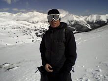
 Cheese'n at the top... Hi Cyn, wish you were here ;)
 Looking back at the ridge approach.
 The little saddle just before the summit
 Lots of open space to the north (Vasquez Wilderness Area)
 This basin looks like it holds quite a bit of snow during the winter, possible playground, only consideration would be that you would have to climb back out over the divide to get back to your car, as its miles and miles of wilderness to the north.
 Totals for the day 7.5 miles, 4000+ Vertical

No comments:
Post a Comment